
Chris Ford. Day 3.
**Editor’s note** This article was written for Outside Magazine’s “Survive” section. Unfortunately, they ultimately decided not to run it. I still really enjoyed writing it, and I hope you enjoy reading it.
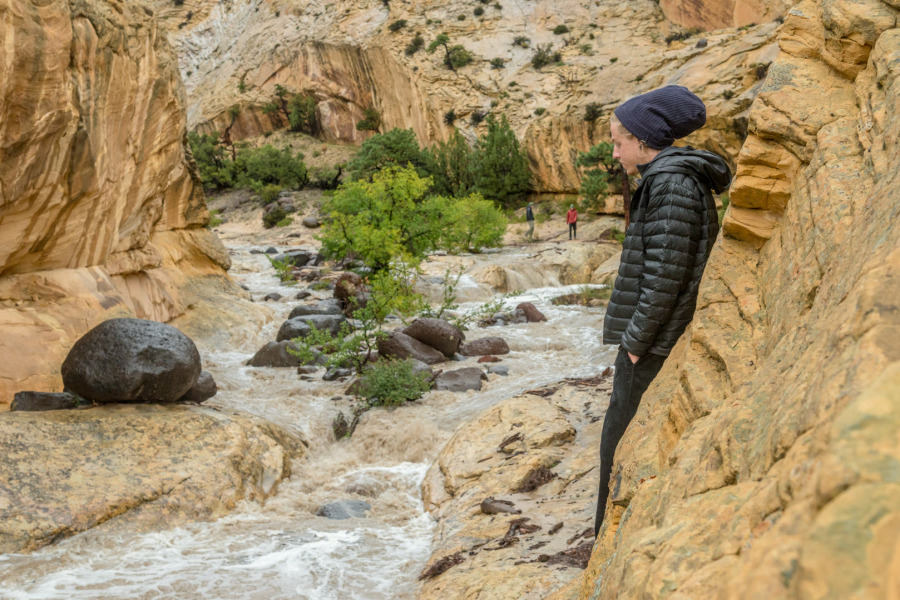
We woke up to the dark echoes of an unfamiliar sound. The canyon roared. Minds began racing; were we high enough? Were we going to need to attempt a scramble up the slick sandstone walls that with one slip would send us tumbling into the clutches of the infamous Death Hollow? Or were we going to escape dry, with the story of a lifetime?
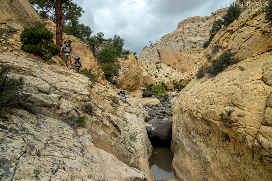
The four others had listened patiently when I told them the plan. It seemed straight-forward enough, and fun. We’d drop into the headwaters of Death Hollow, north of Escalante, Utah, get the long slog out of the way first, stop to waterproof our backpacks, and then head into the narrows to face the chokestones and lengthy swims. Once the perennial flow begins – the not-so-consistent beta had said – the swims would become moderate at worst. This meant that it was the second day that we really had to worry about: the chokestones and the swims in the upper narrows. As I laid out the plan, explaining the lack of beta and all, the four experienced adventurers sitting across the kitchen table from me shrugged with a casual kind of confidence.
Collectively, we had more than 50 years of experience under our belts. The competency level was exceptional: Jacqui Edgerly is a Black Diamond sponsored skier; Tom Butz is a successful Montana fly-fisherman; James Gorman is a native Coloradan, well-accustomed to wild environments; Chris Ford has extensive experience exploring the high peaks of the Rocky Mountains; And as for myself, I could be considered the desert rat. We’d all had our fair share of “close calls,” but more than just experience in tricky situations, what we all brought to the table was our easy manner; our nonchalant, we-will-get-through-this-without-freaking-out mentality. The last thing you want when heading into any high-consequence situation is a bull-headed macho man. The mutual respect was high, and so was the stoke. But as we all know, that doesn’t mean shit.
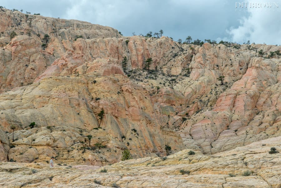
The Death March. AKA: The upper reaches of Death Hollow.
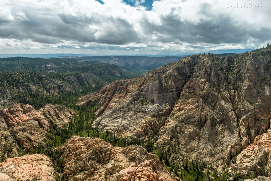
West rim of Upper Death Hollow.
The weather forecast seemed okay: 40 percent chance of rain on Monday, surrounded by 20 percent chances Sunday and Tuesday. But as we embarked on Sunday’s death slog, the skies greyed before us and we began to worry about the lack of rain gear and lack of tents. If we would have had a barometer with us, it would have been plummeting quickly, and we knew it. We quickened our pace, tried to keep our anxiety in check and after several failed scouting trips up the canyon walls, we eventually found a shallow, but long alcove, right where the canyon dove into the never-ending narrows. It wasn’t ideal–being only 10 feet above the canyon floor–but we would be dry and free of any flowing water, for the time being. We didn’t have tents, so yes, we needed to find an alcove. I take the blame for the lack of tents and rain apparel, but c’mon, we were going to be swimming and wading all day Monday, so what’s the point of rain protection? And plus, there would be plenty of overhangs along the way. At least, that’s what I had assumed; I hadn’t actually been in the top half of Death Hollow. But honestly how could it be all that much different from the lower half?
The food came out and the clouds held. We sipped on our whiskey and made tea. The night fell over us and we carved out our individual sand-cots under the gentle overhang of the alcove. The wind was calm, mildly exfoliating our exposed skin with the fine grains of sand, but as the night got darker, the clouds began to tease us with the occasional raindrop, forcing us to roll over and tuck ourselves just a little bit deeper into the safety of the canyon wall.
Inaccessible watering hole.
The morning broke with promise–and a slight rearrangement of sleeping locations–but all in all the skies looked to be in our favor. The sun warmed our faces, maybe a little too much, and the sunscreen was passed around. Camp was quickly packed into our wading-prepared backpacks and before we knew it we were on our way to find a “clean” watering hole in which to pump.
The water hole was sunken down in the wash and surrounded by chokestones, allowing only a few hands to work at a time, so I decided to take my morning “nature calls” look around. I scrambled out on the north side of the canyon. Junipers and Pinions made up the flat, wide shelf that bridged the main canyon with the right-hand canyon. Standing above the confluence, I could see that if we dropped in from our watering hole, we would be in the canyon for good. Like the beta suggested, there would be no exits from that point on, until the perennial flow, several wades, swims, and squeezes later, carved a wider, mellower waterway. But before I could get too excited, the sun disappeared. I turned my gaze toward the west only to find a looming cloud with a dark curtain of rain revealing its intended purpose.
The crew had barely topped off the last bottle by the time I returned. My voice taking on an unusual edge, I told them that we had five minutes to get back to our alcove. Maybe they sensed the imminent danger themselves, or maybe it was my unusual tone, either way, they wasted no time. As we skirted a hole above our pumping one, the sky let loose, dumping water from a million invisible fire hoses. The rocks reflected the grey above and we started to question the forecast with obvious contempt. Our sun protection seemed ironic at this point, and we laughed to hide our growing anxiety. The storm had changed our plans: we all wanted to head down the drainage and have the trip of a lifetime, not sit in a shallow alcove, wondering who’s going to make the first suggestion to retreat.
As quickly as the clouds had rolled overhead, they vanished. We briefly discussed the sunny opportunity, but opted instead to climb the south rim and reconnoiter. The landscape rolled and dove into drainages, all leading into Death. The cliffs and plateau to the west formed the horizon, and to the south and north, even to the east, were dark clouds with white cumulus towers. High above the white fluffy towers were wispy cirrus clouds. The sun lingered and quickly dried the sandstone. Our anxiety subsided and we pushed south, up and down, following contours, and continually taking notes on the map. We eventually came to a high point and could see the far southern reaches of Death Hollow, where the Boulder Mail Trial possibly entered and exited the canyon. To the southwest we saw fins of sandstone sloping down off of the plateau. We noted one fin in particular that looked like an exit, and possibly a way to Roundy trail. To the north we could see the Aquarius Plateau off of which we had descended and to the northwest and west, we could see the dark, deep serpent of Death Hollow.
We made it back to camp as another veil swept over us. We lit a fire and huddled around it, watching human kind’s first home entertainment-system. We drank our remaining whisky and methodically made dinner, making each task last longer than necessary. The coals died down with the rain and our eyelids won the battle. We found ourselves bunched together, squeezed against the back of the deepest part of the alcove praying that the morning would bring lasting sunshine. The forecast had said tomorrow only had a 20 percent chance of rain. Maybe today’s storm was it.
Recon.
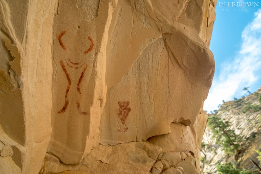
Pictographs at camp.
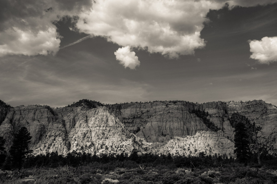
I dozed off to floating dreams of wading, clambering and squeezing down the infamous canyon. The canyon so daunting that it was named Death Hollow and part of it was even formed into a wilderness in 1984, Box-Death Hollow Wilderness. The upper stretches of the canyon have no trails nor cairns, requiring advanced orienteering and climbing skills. The canyon begins under the canopy of the Aquarius Plateau, North America’s highest forested plateau, averaging 10,500 feet, and flows north to south through monoclines, where the colorful striations of sedimentary rock expose oranges, reds and whites. The Hells Backbone road circumnavigates Death’s upper reaches and at one point goes over a single-lane bridge with thousands-of-feet plummeting on either side to one of the many tributaries that make up the head of Death’s watershed; easily more than 20,000 acres of exposed sandstone that retains little water.
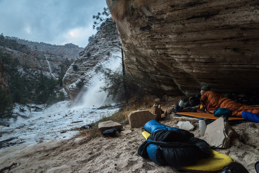
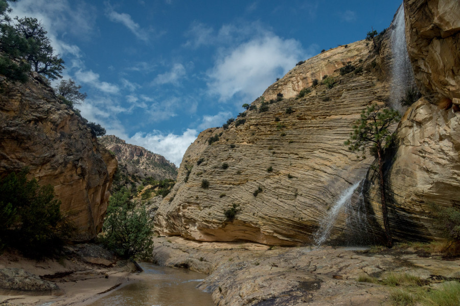
The sound was deafening. I’ve heard tales of a freight-train-like sound booming ahead of a flash flood, and in this instance, that seemed like an inadequate description. This sounded like Niagra fucking Falls. Maybe it was fear accentuating the sound, but we all sat up at the same time, our eyes bulging and our hearts pumping. The beams on our headlights filled the narrow waterway below our alcove to see it filled wall to wall and rising. We quickly tidied up camp, Tom even going so far as packing his sleeping bag. We were clothed in no time, pacing back and forth along the 10-foot rim that protected our camp from the frothing and churning water. But it wasn’t the water in the bottom of the canyon that was booming, it was the horizontally blasting cannon that was shooting by our heads. It was that little stained drip, drip of a tributary that hours earlier seemed so innocuous that we hardly took notice. That small, cute flow of water that had a perfectly placed Ponderosa Pine at its base and small ferns growing out of the fissures in the rock. But now, now it was booming with the violence of an 18th century battalion.
We had marked a route to higher ground during the daylight hours, but now we didn’t really want to rush out of our sanctuary, loud and deafening as it may have been. So we stood there, watching the water creep higher and higher, praying it didn’t overtake a beige stone that we had marked the “bailout stone.”
“Is there going to be a wall of water, like in the movies?” someone yelled.
We decided no, but we were prepared to bail out as soon as our marked stone disappeared. We stood there in the dark, flashing our lights between the turbulent stream below and the booming cacophony above. The sound subsided a bit, and in a sudden release of exasperation, we lit a fire. We laughed, uneasily, but collectively and without words, decided that we were okay. We formed a semicircle around the fire and let the familiar crackle and glow comfort us. The creek continued to ebb and flow in sync to the sound of the waterfall, eventually waning with the glow of the coals. Our fear gave way and we somehow found confidence to slip back inside our sleeping bags.
Morning wakeup call.
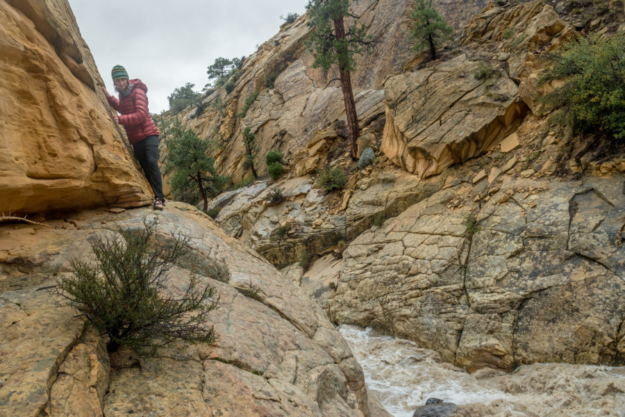
Jacqui exploring our options.
As dawn arrived, we were shaken awake once again by the booming cannon. This time though our fear was controllable; we could see what was going on. Our hearing had adjusted to the danger level and upon inspection, our marked rock from the night before was still visible – but the water was rising! We assessed the situation, talking calmly amongst ourselves. Not one of us took control of the situation. We were rational, respectful and above all, ended each point in agreement. At this point I realized I couldn’t have asked for a more level-headed group of people. We talked about crossing the creek, how best it could be done. We weighed the option of retreating back to the car, walking through the scratch and pull of the underbrush through the never-ending Ponderosa valley we had dubbed the Death March. We talked about our recon hike the day before. We even talked about how lucky we had been to find this one, and seemingly only, alcove of safety. We finally agreed the safest bet was to fill up the dromedaries and head back to the truck, 10 miles and a few-thousand-foot climb away. As the conversation circled around the group with an invisible talking stick, we all had our say, and it became clear that the most rational decision was winning: We would retrace our steps back to the truck. It was familiar, we knew what lay ahead, and above else, there was a vehicle to take us home. But in the back of each of our minds, no one wanted to retreat. No one wanted to revisit that 10-mile slog, especially after just suffering through it two days ago. And so there it was. On the precipice of retreat, nearing the end of our palaver, the voice of reason seemed to stand tall.
But breaking the silence, stopping the retreat almost in its tracks came the explorer. Chris spoke up. “I think we should see if we can get up that fin we saw yesterday. And if we can’t then we will go back to the car.”
One by one, almost reluctantly, with minds nearly made up on retreat, we agreed. And seemingly in unison, the sun came out, refilling our adventure reserves. The creek dropped and before long we were standing on the south rim, looking down at our camp basking in the sun, with the waterfall still booming overhead. It was surreal looking at the cascading water under blue skies. So quickly had it changed, and so quickly would it change again. We had to push on. And we would.
Flash flood and blue skies.

Scanning the fins.
The fin turned out to be the ace we needed to draw. Our five-card team scrambled up the rim of the plateau with ease. We summited and realized we had cell range. I made a few phone calls and arranged a pickup. Now all we had to do was find the dotted line named Roundy trail. We pushed on, navigating through a sea of Pinion pines and Junipers, clambering up and down hidden draws. We made sure to hit the far side of the plateau north of the Roundy trail, ensuring we didn’t miss our route down. We stood there looking down at Pine Creek, the perimeter of the Box-Death Hollow Wilderness, and we knew were safe. We had survived the clutches of Death.

Tom and Jacqui looking at the southern reaches of Death.